Are you excited to hike around the 8th-highest mountain in the world but aren't sure how to plan your route? Do you want to know which villages to take breaks in, how steep the uphill climbs become, or how far you will walk each day? This Manaslu circuit trek map shows you the answers. Follow the path and learn even if it is difficult. Without proper mapping experience of this remote area of the Himalayas, sometimes routes don't even have signposts, and navigating becomes quite challenging and tests your overall preparation.
Every year, thousands of adventurers come out to trek in Nepal, and behind every successful journey are seasoned guides and porters with local expertise. These local mountain professionals figure out the weather ahead and how the trails might fluctuate as you are trekking along with them, to sculptural tactics that make your trek a unique experience. Having the guide's knowledge combined with your own navigating experience contributes to a safe and memorable trip around Mount Manaslu.
This extensive guide will take you through the Manaslu trekking route map in detail, splitting the entire circuit into sections you can digest before your visit. We will take you through daily distances, elevation profiles, where villages are located, where the highlights are located, and important mapping tools to prepare you for this incredible 177 km trek. If you're evaluating this trek against others in the Himalayas or are preparing to go on your first high-altitude trek, this guide will provide the mapping knowledge you need to effectively navigate one of the more pristine trekking destinations in Nepal.
Why You Need a Map for the Manaslu Circuit Trek
The trekking map of the Manaslu region is your best friend in the remote and rugged landscape of the Himalayas, where navigation obstacles lurk at every bend. Contrary to the well-trod paths of the Everest Base Camp Trek and the Annapurna Circuit, Manaslu is less developed, with fewer signposts and limited infrastructure. A trail map of the Manaslu circuit serves as a compass to monitor your progression daily, locate evacuation routes in the event of an emergency, and generate time plans based on true distances.
There are serious weather variations and changes in the Himalayas, and having a map in physical form along with digital devices means you will never truly be lost if your devices fail. The trail will lead you over suspension bridges, through thick forest, and up the inhospitable Larkya La Pass at 5,160 meters. Your map, again, is vital because it provides real information on how much altitude gain you will experience and points out structurally appropriate acclimatization stops to help avoid altitude sickness.
Overview of the Manaslu Circuit Route
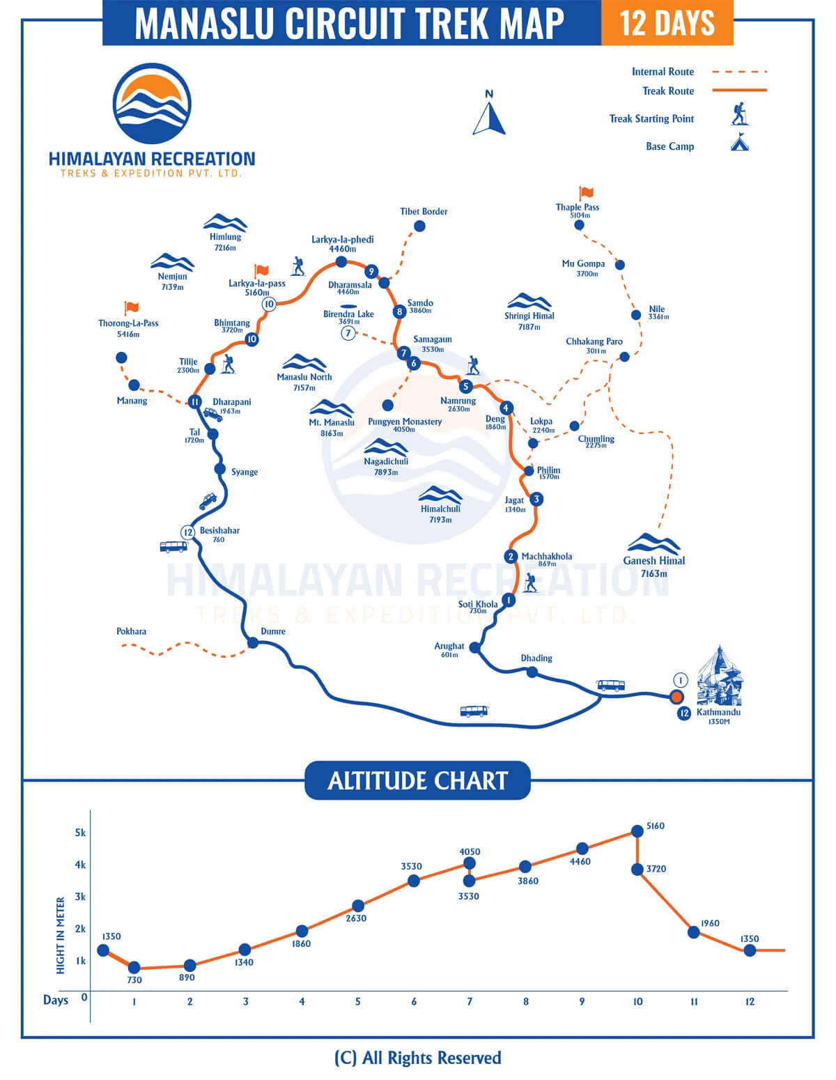
The Manaslu circuit map describes a counterclockwise expedition that takes you in the general direction from Soti Khola and ends in Dharapani. This 177-kilometer trek takes you around Manaslu (8,163m), going through the Budhi Gandaki Valley with unspoiled scenery, from subtropical forests to alpine meadows and glacial environments.
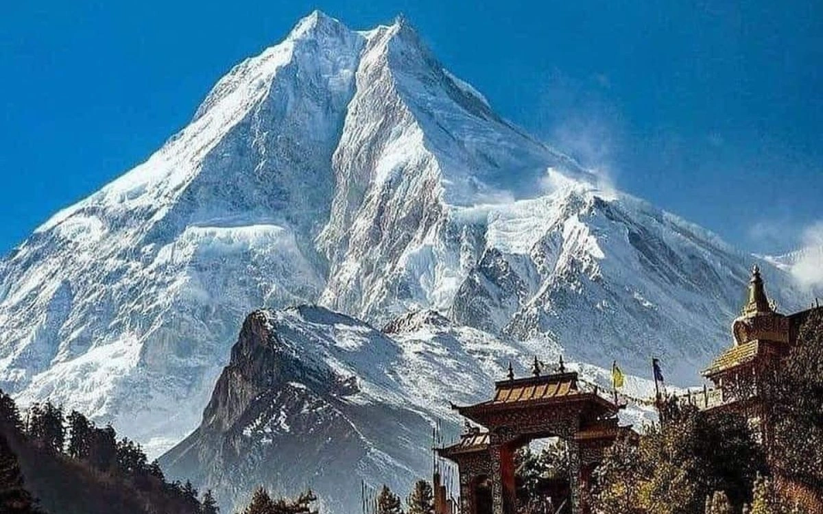
Mount Manaslu peak towering above a Tibetan Buddhist monastery
The path leads you into the restricted Manaslu Conservation Area, requiring special permits to trek, unlike the more accessible Langtang Trek. A refresher is that during your trek, you will find yourself in traditional Gurung and Tibetan villages where Buddhist culture is easily seen; travel is often adorned with historical monasteries, prayer wheels, and mani walls, all marking the spiritual importance of the area.
A quality Manaslu trek map should include some topographical details showing elevation changes, locations of villages, resources for crossing rivers, and potential hazards. Digital version maps often include GPS coordinates that can sync with phone apps; although you can never go wrong with a paper, waterproof map in case your batteries run out or the weather turns on you.
Important map characteristics consist of a scale and distance markers indicating distances in the field, elevation contours indicating how steep the climbs are, village icons marking where to find accommodation in trekker lodges, river crossings marking where bridges can be found, and alternate routes showing backup trails in case of emergencies. Many trekkers combine several mapping modalities, using printed maps purchased at Kathmandu shops, with a GPS device that is preloaded with trails throughout the Himalayas, as well as using an offline mapping app on their smartphones.
Day 1: Soti Khola to Machha Khola (14 km, 6-7 hours) - The journey begins with a gradual ascent along the Budhi Gandaki River, crossing suspension bridges through Sal forests.
Day 2: Machha Khola to Jagat (22 km, 6-7 hours) - The trail continues upstream with moderate climbs, passing through Tatopani before reaching the checkpoint village of Jagat.
Day 3: Jagat to Deng (19 km, 6-7 hours) - Entering deeper into the conservation area, the landscape shifts toward pine forests with increasing Tibetan influences.
Day 4: Deng to Namrung (18 km, 6-7 hours) - The valley widens as you trek through Ghap, with stunning views of Manaslu's peaks emerging.
Day 5: Namrung to Samagaun (18 km, 6-7 hours) - Passing through Lho village with its magnificent monastery, you reach Samagaun, a crucial acclimatization stop.
Day 6: Acclimatization in Samagaun - Rest day for altitude adjustment, with optional hikes to Manaslu Base Camp or Pungyen Monastery.
Day 7: Samagaun to Samdo (8 km, 3-4 hours) - A short trek to the final village before the pass, allowing further acclimatization.
Day 8: Samdo to Dharamsala (11 km, 4-5 hours) - Ascending to the base camp for Larkya La Pass crossing at 4,460 meters.
Day 9: Cross Larkya La Pass to Bimthang (23 km, 8-10 hours) - The most challenging day involves crossing the 5,160-meter pass and descending steeply to Bimthang.
Day 10: Bimthang to Tilije (20 km, 5-6 hours) - Rapid descent through rhododendron forests into the Annapurna region.
Day 11: Tilije to Dharapani (17 km, 5-6 hours) - The circuit concludes as you connect with the Annapurna Circuit route.
Elevation Profile of the Manaslu Trek
It is important to have an understanding of the Manaslu circuit elevation profile as you make plans for physical preparation and acclimatization. The trek starts at about 700 meters in Soti Khola and steadily ascends to 5,160 meters at Larkya La Pass (the high point), and then descends to 1,860 meters in Dharapani.
Manaslu Circuit trek map showing route, villages, and elevation profile
The elevation gains are gradual, occurring over several days on the trek. With the addition of rest days, this is a safe rate of ascent for acclimatization. The Villages of Samagaun (3,530m) and Samdo (3,860m) are key acclimatization stops, where trekkers can spend an extra day at each of these villages and thus acclimatize properly before going over the pass.
The steepest/most challenging elevation gain (for one day) is the section from Dharamsala to Larkya La Pass, where an ascent of approximately 700 meters will be followed by a descent of 1,600 meters to Bimthang. The elevation changes are extreme and will require an excellent level of physical conditioning, as it is similar to other, more difficult treks such as the Gokyo Lakes Trek or Makalu Base Camp Trek.
Soti Khola (700m) signifies the starting location with lodges and the last major resupply stop. Jagat (1,340m) marks the first checkpoint, where you will very slowly verify your permits. Namrung (2,630m) is the first village you will encounter with authentic Tibetan Buddhist culture, prayer flags, and four stone houses for lodging.
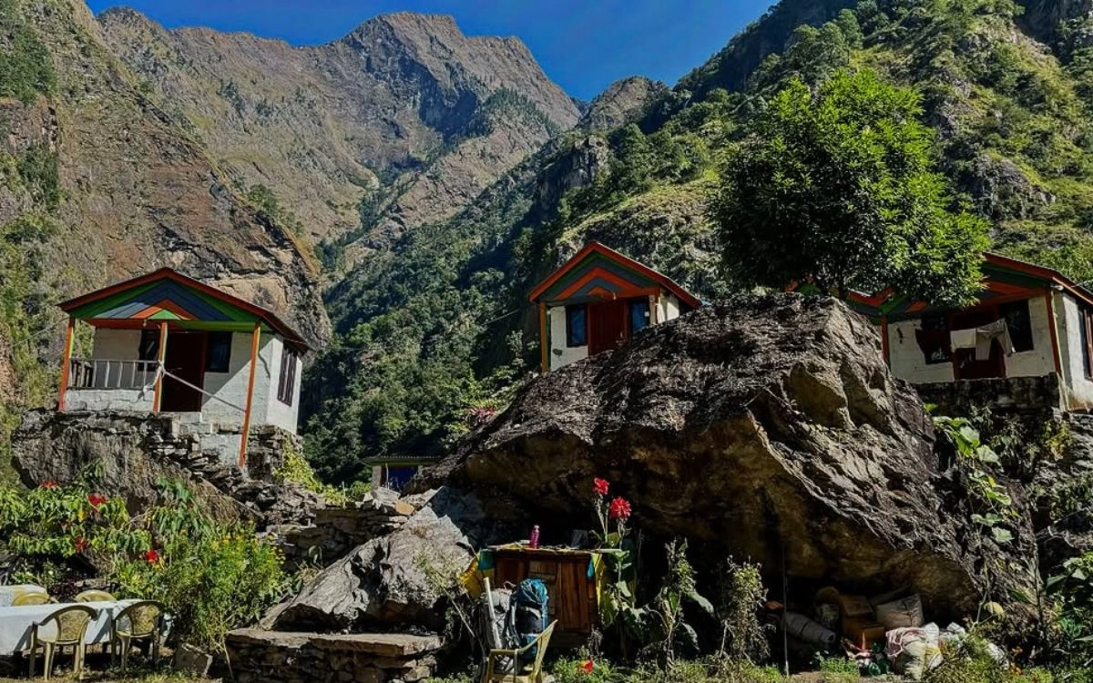
Traditional teahouse lodges built on rocky terrain in the Manaslu region
Lho (3,180m) has an incredible monastery with great views of Manaslu, which is a unique representation of authentic Tibetan culture and heritage. Samagaun (3,530m) is the largest village in the upper regions with several lodges, a health post, and roadside access for excursions. Samdo (3,860m) is the final village before Larkya La Pass, having been a famous trading stop with Tibet many years ago. Dharapani (1,860m) will be the endpoint where the Manaslu Circuit joins the popular Annapurna Circuit trek.
Key Landmarks and Viewpoints
The Manaslu circuit trail map illustrates the many features that shape this remarkable trek, known affectionately as 'Manaslu' or Manaslu Trail. Throughout the course of your trek, you will always have the main highlight of Manaslu Peak (8,163m) dominating the skyline, in view from many locations as you traverse around the mountain. Some of the best views of Manaslu can be taken from Lho village and Samagaun.
Larkya La Pass (5,160m) is the pinnacle of the trek, with a complete 360-degree vista which offers sights to admire and a background of Himlung Himal (7,126m), Cheo Himal (6,820m), and Kang Guru (6,981m) - a majestic panorama. Vibrant prayer flags are blowing in the brisk air, marking a holy altitude crossing. Pungyen Monastery, in the vicinity of Samagaun, offers a chance for cultural immersion, whilst also marking a stout acclimatisation hiking point. Birendra Lake sits at an altitude of 3,450m and is accessible to you on your acclimatisation days from Samagaun, offering an extraordinary vantage point for stunning images, with reflections of peaks in the lake.
The trekking route map for Manaslu also shows some enticing side trips. The popular extended option is to trek to the Tsum Valley, adding 5 – 7 days to your travel itinerary to venture into the sacred Himalayan valley inhabited by Tibetan Buddhist communities. This side valley is even more remote than the main circuit, and also provides a more in-depth experience with cultural immersion, similar in experience to remote trekking experiences of Upper Mustang Trek or Kanchenjunga Base Camp Trek.
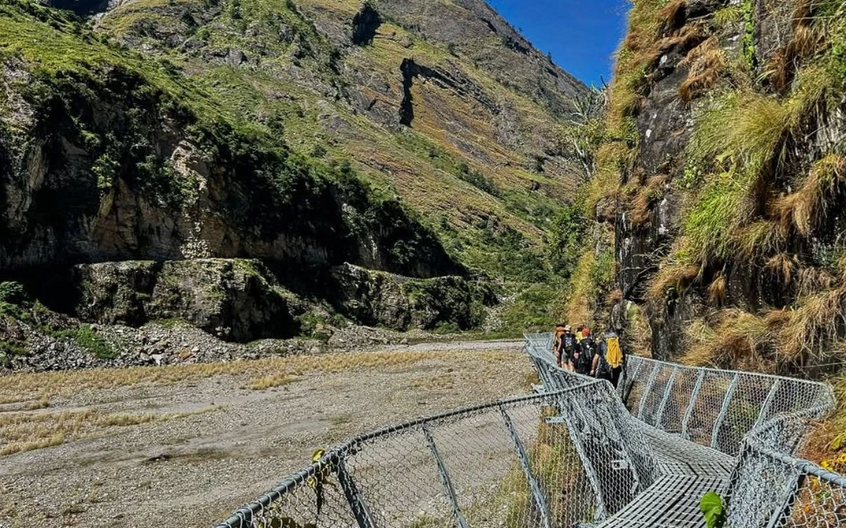
Trekkers crossing a suspension bridge along the Manaslu Circuit trail
For those looking for a little adventure on the trek and want to get closer views of the glaciers, the Manaslu Base Camp day hike from Samagaun is an option, but be aware of altitude challenges. The hike is strenuous as the round trip takes 6-8 hours, so this hike should only be considered after adequate acclimatization. For a gentler option, trekkers can hike to Pungyen Monastery on a rest day to combine cultural immersion and acclimatization on the trails.
Manaslu Region Trekking Maps
Various types of maps may be used for different purposes during your journey to Manaslu. Topographical maps display all the features of the terrain, elevation changes, and geographic information you will need for navigation. Trekking route maps will focus specifically on the trails, villages, and accommodation points, which can help you with your daily planning.
GPS maps can be uploaded and utilized on your computer or smartphone and provide real-time tracking and location functionality. For example, apps like Maps.me allow you to download the maps ahead of time so you can use them without access to the Internet. Cultural maps will display cultural features along the way, such as monasteries, stupas, or sites of cultural significance. Emergency maps will show locations of helicopter landing zones, health posts, and evacuation routes, which can be especially useful in an unforeseen situation or during safety planning for a remote trek like the Dolpo Region Trek.
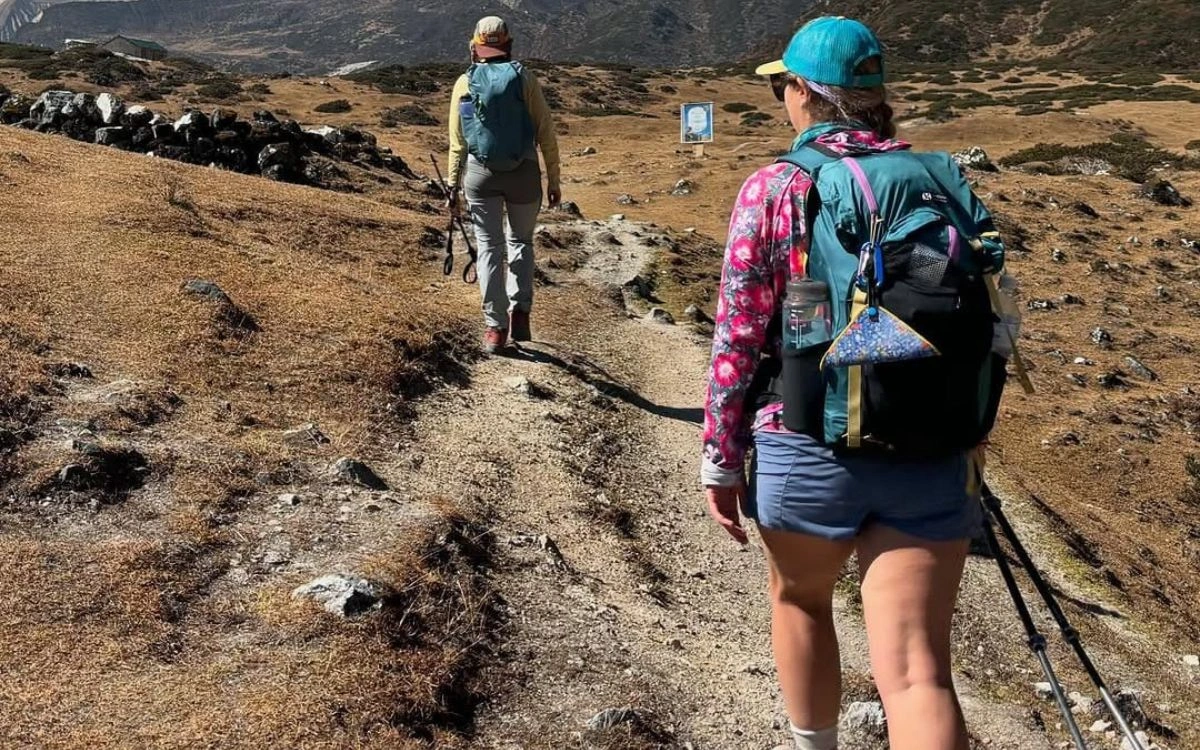
Trekkers hiking along a high-altitude trail in the Manaslu region
FAQs
How difficult is the Manaslu Circuit Trek?
The Manaslu Circuit is classified as moderate to difficult. It is very similar to the Annapurna Circuit, but not so populated and definitely more remote. Physical fitness, tolerance for altitude, and mental readiness for long days of trekking are all important.
Do I need a guide for the Manaslu Circuit Trek?
Yes. Nepalese law does not allow independent trekking. Trekkers must be part of an organized group that includes a licensed guide to ensure the safety of trekkers in this restricted conservation area.
What is the best season to trek the Manaslu Circuit?
The best months to trek Manaslu are the spring (March-May) and the autumn (September-November). These months are usually when the skies are clear and temperatures are moderate. Winter can pose difficulties due to snow, while the monsoon can create difficulties on the trails.
How many days will it take to complete this trek?
The normal itinerary lasts between 14-18 days; this includes acclimatization days and travel days to and from Kathmandu. Attempting the trek in a rushed fashion may lead to symptoms of altitude sickness.
Conclusion
The Manaslu circuit trek map elevates your Himalayan journey from uncertain wandering to informed exploration. A detailed mapping resource provides you with a sense of distance, a sense of elevation, and detailed locations of villages, all of which make it easier for you to set your own pace, understand geographic features, and prepare for the daily challenges of trekking.
Whether you are a returning trekker who has traversed some of the more adventurous routes like the Everest Three Passes Trek or simply looking for your first taste of running in the Himalaya, if you have experience or are planning your first adventure in the Himalaya, proper map knowledge improves safety, appreciation for cultures, and overall satisfaction with the journey.
The Manaslu region trekking map illuminates not only trails and hiking elevations, but the intricate storyline of communities that are in spite of their remote location, function beautifully in the mountain outback, and the raw amenity of the Nepalese wilderness. As well, ready to start your Manaslu adventure? Expert comfort and assistance are available. Contact us at Himalayan Recreation to start planning your culinary adventure in the Himalaya today.
-3.webp)
-3.webp)
-2.webp)
-4.webp)